Lesson Objectives:
- describe the history of map-making in Africa
- recognize different types of maps of Africa
- collect and describe maps of your selected African country
Creating Africa through map-making
Cartography is the study and practice of making maps, and map-making plays a central role in the ways that geographic spaces (such as the African continent) are represented to a broad audience. Maps provide a visual representation of particular traits that characterize an area. The traits can be physical, such as roads and waterways, or abstract, such as political boundaries.
Geomorphic and Political Representations
Students are usually most familiar with maps that represent the political boundaries of nations such as the map to the right which depicts the national borders of African countries. It is important to note however, that national boundaries are abstractions; this means that they are created in the process of map-making. In most cases, borders are created (and enforced) by those who are in power, and the representation of territories through map-making is oftentimes an expression of power. When we address colonialism in the upcoming lesson, we will explore the ways that contemporary political maps of Africa are rooted in an historical event called the Scramble for Africa, when European representatives congregated in Berlin, Germany in 1885 and carved out their territories on a map of the African continent. At that time, the borders created by colonists intersected indigenous ethnic and linguistic groups and consolidated rivaling groups. Today, a considerable amount of the ethnic struggles and border conflicts taking place in Africa can trace their origins to the arbitrary creation of borders by 19th century European occupiers. This is why borders are constantly shifting according to political and social upheavals, and it is therefore always important to ensure that you are using the most current political map of Africa. Unlike the majority of maps available on the internet, the political map depicted here includes the new nation, South Sudan, which recently gained independence in July 2011.
Political Conflicts = Border Conflicts
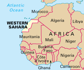
You may also find different political representations that express contemporary struggles over sovereignty and territoriality, known as disputed territories. Morocco, for example, is currently represented in two ways according to the political affiliation of the map-maker and the person using the map. The map of Africa here depicts Western Sahara, which has been declared independent from Morocco by the Polisario Front. Maps of Morocco and the Western Sahara are widespread throughout the internet, yet they can elicit outrage to the wrong audience. During a conference in Rabat, Morocco, an American researcher offended a room full of Moroccan nationals by displaying a map of Morocco with the Western Sahara in his Powerpoint presentation. This is why it is very important to do your research and consider your audience when you are referring to or using a map of a territory. The map to the right exists in the Food & Agricultural Organization website; FAO works closely with the Moroccan government. Similar disputes include Somaliland, the border between Ethiopia and Eritria, Cameroon and Nigeria, Uganda and Rwanda, South Africa and Swaziland, and many more.
Mapping the Environment
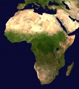
Maps of Africa can also represent environmental features which are significant because the natural environment plays a direct role in shaping the circumstances experienced by people living in Africa. The satellite image to the right offers a generalized depiction of the spatial distribution of arid and densely vegetated environments. It is evident that the most densely vegetated areas of Africa exists along equitorial band that crosses the center of the continent. This area is characterized by rainforests and rich biodiversity. The area is flanked by the Sahara desert in the north and the Kalahari desert in the south, both deserts are two very distinct ecosystems. We can also see the African Great Lakes which include Lake Victoria (the second largest freshwater lake in the world), Lake Tanganyika (the longest lake in the world), Lake Malawi, Lake Turkana, Lake Albert, Lake Kivu and Lake Edward. Like political borders, place and feature names in Africa can also reflect the colonial legacy.
Know Your African Countries
By the end of this course, you should be able to recognize and identify every country in the African continent. This may sound daunting, but learning the African countries can be fun. Here are a few links to online map quizzes to help you test your knowledge and practice memorizing each country. Take note of your initial score when you first take each quiz to compare it to your abilities by the end of the semester.
- Label each country on the continent
- Find each country on the continent
- Select the country on the continent (If you have kids this one is a great game to play together.)
African Map Gallery
Visit the University of Florida’s Map and Imagery Library Collection and explore the different representations of the African Continent. Consider how the different natural and political environments shape the experiences of African peoples and cultures in different ways. In the exams, you will be expected to identify each country in a political map of Africa and know significant environmental features in the continent. You can practice learning the countries by using one of the map tutorials listed on the map resources page link above. Now is also the time to begin collecting and reviewing maps of your selected country.
References and Resources
- Frisht, Kathrin and Isabel Voigt. 2008. “Local knowledge is wonderfully good, but …” – African Knowledge in European Maps. Symposium on “Shifting Boundaries: Cartography in the 19th and 20th centuries” Portsmouth University, Portsmouth, United Kingdom, 10-12 September 2008
- Bassett, Thomas. 2008. Maps and Mapmaking in Africa. Encyclopedia of the History of Science,Technology and Medicine in Non-Western Cultures.
For Discussion in Canvas
Embed a few images of different maps of your selected country. Submit a 150-word description of the maps explaining notable features such as waterbodies, transportation networks, landscapes, cities, ecosystems, etc. Respond to at least two other student submissions comparing your country to theirs. (Be sure to reference the source of your map if it is not included in the map itself.)


